Sunday 31 October 2010

A Case of the Bends?

I looked on Wikipedia. The Bends is a condition suffered by divers arising from dissolved gases coming out of solution into bubbles inside the body on depressurisation.

I didn’t get that sort of The Bends.

I got this sort....


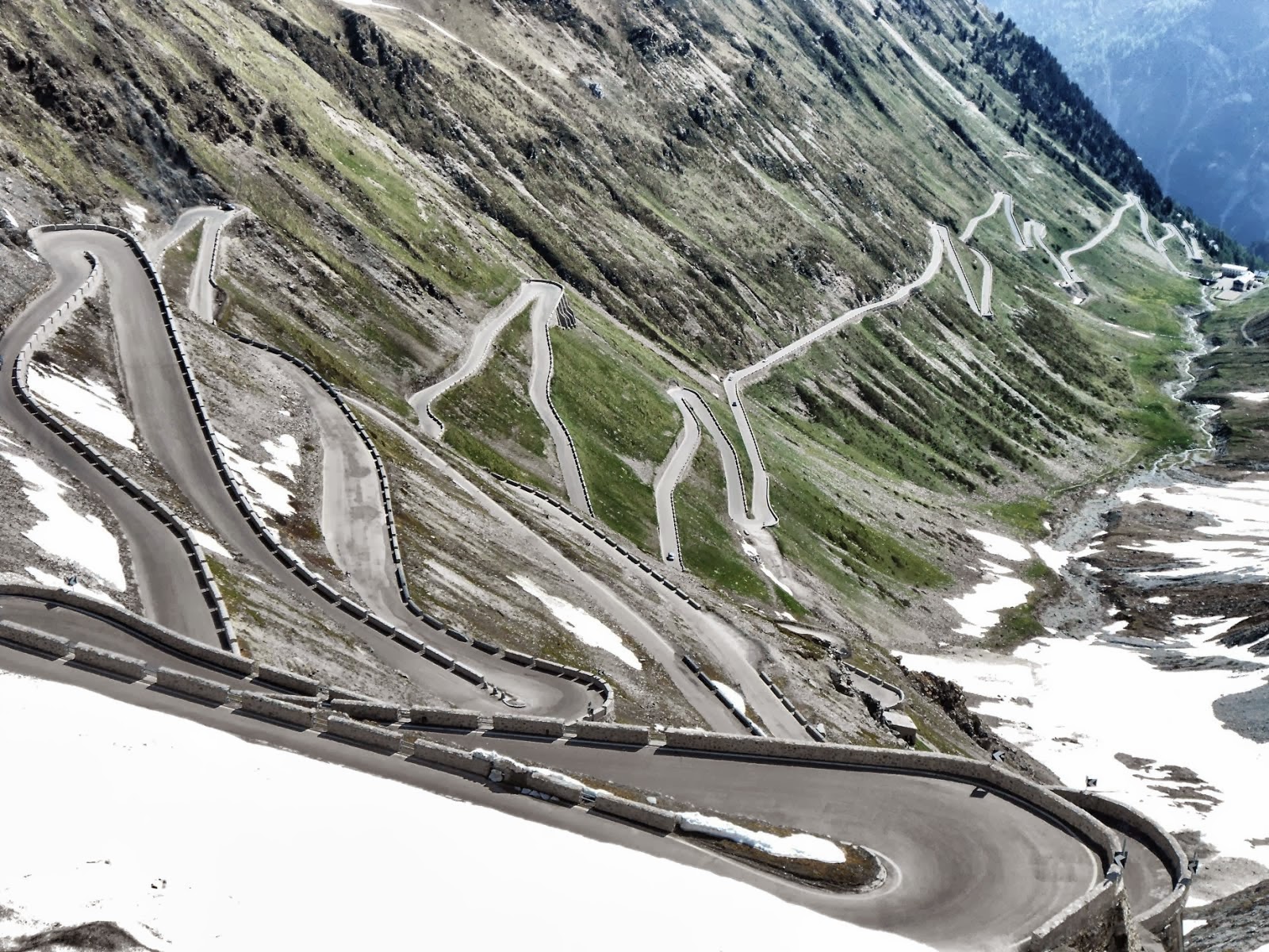
I had ridden through Groveland just to the west of Yosemite on the previous evening and found these bends on California State Road 120. It was downhill and beginning to get dark. I rode to the bottom of the 4.2 mile road and turned around and rode back up. I loved this road as not only are the bends so great, it has a brand new road surface and the speed limit is 55mph. Whey-Hey!! Back at the top of the hill I found a hotel so I could ride the road again in the morning, take some pictures and make a video of it.

The next day, I rode it three times.

Here are some of the pictures I took of the bendy road....


A little further west I found the Don Pedro Reservoir, or at least part of it as looking on the map, it is huge....


I stopped for a while in a very pretty town called Jamestown, which is very small but it does boast its own Harley-Davidson dealership....


I had to change my plans slightly on this day. I had intended to ride State Road 4, Ebbetts Pass, across the Sierra Nevada mountain range, but I had heard this was closed due to the recent snow. I went into the Jamestown H-D dealer and talked to them about the alternative routes I could take. After talking the options over with them and I decided to take Sonora Pass and I am glad I did!

Sonora Pass has two distinct sections. When riding from west to east, the first and longest part from Sonora to Dardanelle is pretty with many long fast bends, but as it is in the trees, almost no view. There are some great trees however....


The second part is got exciting just after I saw this sign.... yes, that does say 26%.... it’s not all at that slope but parts of it are....


It is difficult to stop to take pictures as the road is not very wide and doesn’t contain many places to safely park the bike. When I could I did pull over to take a picture of the view....


There was snow on the ground from about 8,500 feet up. Thankfully, the pass road had been cleared of snow because it rises to 9,643 feet. It was a little chilly up there....


So used to riding in hot weather, every day I stock up with plenty of fluids to take with me. Mainly water, but always lots of cold drinks. I am far too used to this, because on this day I forgot to take the cold weather into account and I should really have been filling my flask with a hot drink instead of iced water! Duh!!

Today was a bright sunny day, blue skies – a wonderful day to be riding. It was cold but I didn’t care. I cranked up my heated grips to the max and put my thin gloves on as this is much more enjoyable than riding in bulky thick gloves. The ride over Sonora Pass was fantastic due to the incredible scenery and the wonderful road. I loved the ride. The temperature was in the 40’s and it was cold but I didn’t care. There was almost nobody else on the road. The hardest thing I had to think about today was making sure I read the line of the road correctly as it dived in and out of the bright sunlight and the dark shadows. What a great ride!

I wondered if I should stop and put on my thicker gloves, waterproof / wind roof over-trousers and a bluff or two, but I didn’t want to stop because I was enjoying the ride so much. I kept riding and just accepted the cold.

I did want to get a picture of the Leading ladies by the snow....brrrr.......


After passing the summit of the road I came down the other side of the mountain to be rewarded with more great views and scenery....


After the pass ended, I rejoined US 395 heading north. I spotted these t-shirts on a barbed wire fence and stopped to investigate.....


The t-shirts appeared to be mainly from fire fighters. There was a memorial plaque at the end of the line and I realised that this was in honour of forest fire fighters that had died in their (what I assumed to be a) C-130 fire fighting plane. I later looked it up on the internet and that was indeed what it was. I found a video of the plane crash and I can recall seeing the video before, as it was very dramatic as the wings fell off the plane. The memorial plaque must be located near where the plane crashed. As the memorial says, Steve Wass, Craig Labare and Mike Davis gave their lives trying to save a community.


Further north I stopped by Topaz Lake....


The guys at Jamestown Harley-Davidson had suggested I stay overnight at Virginia City. The road I took (US 50) to get there was not a good one, with lots of traffic and the views were nothing to write home about. Virginia City is an old mining town and its main street is full of character. It was about 5pm and almost everything was closed! I found a hotel to check into, and managed to find I saloon that sold pizza and had the baseball World Series game on a huge TV screen, so I settled in and watched San Francisco Giants beat the Texas Rangers in this second game of the series. I am beginning to understand the rules of baseball now, so I enjoyed watching this. Beer, pizza and baseball – a good combination!

I had arrived too late to take any pictures that evening, but I did so the next day....

----------------------------------------------------------------

The next morning, I went downstairs in the hotel in Virginia City in search of breakfast, but they don’t serve food. I went for a walk and discovered the Place Hotel serves breakfast but doesn’t open until 0830. I walked around the small town taking some pictures and went back to my hotel. The bar was open and people were sitting around and I couldn’t at first work out what was happening. I sat down and asked why these people were in the bar and got chatting to a guy called Mark, his wife and three really pleasant children. I was told there was a ghost tour around the town the previous night which included the hotel I was staying at – the Silver Queen. They apologised for making a lot of noise, but I had slept right through it.

There was a radio show being broadcast from the hotel. K-Bull 98.1 was the station and they were talking about the events of the night before. The two broadcasters had been up most of the night as part of the ghost tour as well.

The bar of the Silver Queen early in the morning....


The radio show presenters, err, presenting, or is it broadcasting....


Mark, his family and I went off to the Palace Hotel and shared an enjoyable breakfast. I asked each of the family members that after their nights events, on a score where 0 means not at all and 10means totally believe, did they now believe in ghosts. All of them scored it about a 7 or an 8, even Mark who says beforehand he was totally sceptical, like me. They told me of a few events from the night before where they could smell a fire/smoke in one building where somebody had died in a fire, marks appearing on a window and a cold feeling in one room. It was enjoyable talking to them and as a bonus, they bought my breakfast for me!

A few pictures from my walk around the town....

The main street, called “C” street. I just looked on a map, the street go from A street to R street. The miners who first lived in the toiwn were obviously not a very creative bunch!....


The wooden sidewalk....


The Red Dog Saloon (proprietors of Pizza and beer from the night before)....


The sign on the side of the Bucket of Blood Saloon building. What a great name!....


I am glad the guys at Jamestown H-D recommended Virginia City to me.

If the road leading to Virginia City was not a good, the one leading it was very good, with its long sweeping bends. This was State Road 341 and the 431 all the way to Lake Tahoe. I knew a storm was going to arrive in the mountains later that day, so I was keen not to hang around Tahoe for too long as I wanted to get to a lower elevation as snow / rain was forecast.

I did manage to stop a few times near Lake Tahoe.....

The view looking down from an overlook on SR 431 as it approaches Kings Beach....


I didn’t quite get my feet wet, but it was close....


Leaves (note my botanical expertise) near the lake edge....


Looking down at the rocks on the east side of the lake. You can judge the size of these rocks by looking at the person standing on the top of one....


The Cave Rock and its road tunnels....


A beach that I imagine gets busy in the height of summer is deserted at the end of October....


The entrance to a house where Halloween is clearly a big event....


From Tahoe, my route back across the Sierra Nevada mountains was 88, the Carson Pass, which crests at 8573 feet. It was cold again at that level and I was on a mission to cross the mountains as quickly as possible and to get lower, so I only stopped once for a picture of a lake.... I don’t remember what the name of the lake is....


Carson Pass is nowhere near as much fun as either Ebbetts Pass (SR 4) or Sonora Pass (SR 108) so take one of the latter two for the best roads and views. Yes Dom, I now realise Carson Pass is named after Kit Carson and not Johnny Carson!

I started to warm up a little as the road continued it slow climb down the mountains. I wanted to find a Holiday Inn Express to stay at where I could do my weekly clothes wash. Thanks to my GPS, I soon found one.

I walked to the nearest restaurant which was an Italian called Vince’s in West Sacramento. I sat at the bar and chatted to Chris who enjoyed nearing about my tour. It was their Halloween night and all the staff were wearing costumes....

This guys outfit was impressive....


The owner of the restaurant in his costume....


Chris on the right, with another staff member....


I needed to catch up with my blog, so after a meal and a few drinks, I left the staff to their fun.

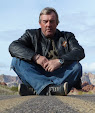
My regular readers will remember Paul, my friend from the UK who rode with me in the New England States, and that his wife Sarah recently gave birth to their son called Jack. Paul just sent this picture of Jack and I have to share it with you. Future biker me thinks?....


Finally, when i was in Jackson Hole I saw a sticker in the window of a car that said “Surf Wyoming”. I took a picture of it as I couldn’t work out what it meant....


Somebody has anonymously added a comment on the post giving a link to explain what it means. Thanks to who ever did that. You can check out what surfing in Wyoming means here.It is very cool!

Saturday 30 October 2010

Magnificent Yosemite

Day 126 saw me heading towards Yosemite.

I went north on US 395. This is a mainly straight, mainly level, but very spectacular road. This is because for a very long way the road runs close and parallel to Sierra Nevada mountain range which includes Mt Whitney, the highest point in California and the highest peak in the contiguous 48 states (those states excluding Hawaii and Alaska). For a couple of hours, the mountains were my constant companion of my left hand side.

Just north of my stop for the night in Lone Pine, is a place known as Manzanar. This is one of 10 internment camps that were used during the second World War to house Americans of Japanese ancestry. The camps were set up soon after the attack on Pearl Harbor. Over 110,000 were held in this way under what must have been difficult circumstances, both politically and in the summer heat in the 36 blocks that were built on the camp to house the prisoners.

Very little of the original facilities remain at Manzanar except the roads and the foundations of some of the buildings....


Two blocks have been built recently to resemble how the original buildings looked. I think this lookout tower is a reconstruction....


The camp had most of the facilities of a small town, including a farm, a post office, a hospital, warehouses and garage buildings as well as administrative offices. One of the most poignant areas was the cemetery where 150 men, women and children who died at the camp were buried. The highest peak in the background of the first picture is Mt Whitney....


The camp reminded me of the internment that happened in Ireland during the IRA terrorist conflict. People who were suspected of a terrorist crime were placed in internment camps, effectively prisons, despite never having been charged or tried for what they were suspected of having done. Those camps caused enormous bitterness on both sides and I suspect Manzanar had the same impact.

I spotted this old barn further along US 395....


Close by the old barn is a great view of the mountains. I just spotted the view as I was turning my bike around after taking pictures of the barn....


Snow was on most of the high peaks and I discovered this started from about 8200 feet up.... I know because I went up that high twice in the next few days....


US 395 is mainly a 4 lane road, but some stretches are down to two lanes. As the road is mostly straight I got a real sense of getting somewhere fast as I passed the mountains by....


It was lunchtime by the time I got to the turn off point for Yosemite and I wanted to warm up slightly before I started to cross the mountains via Tioga pass. It was suggested to me that I should stop for lunch at a particular place in Lee Vining, but I couldn’t find the suggested restaurant. I went back to the e-mail afterwards and discovered it was located inside a gas station. I should read my e-mails more carefully! Anyway, thanks for the suggestion Randal. I did find somewhere else to eat in Lee Vining and another strange co-incidence happened. The bikes I saw with the Swiss flag stickers on in the car park of the hotel I stayed at in Las Vegas were now parked outside where I had stopped for lunch. I noticed the flags as I looked out of the window, so I chatted to the riders of those bikes over my bowl of warming soup!

Before I left Lee Vining I went to see the nearby Mono Lake. The water in the lake is very salty and has a high alkaline content. Over many years this has created tufa towers that rise out of the water. I didn’t have time to walk to the taller towers, so I was content with looking at the lower sections which have grown near to the road....


I don’t know if it happens all year round, but the lake edge was swarming with thousands if not millions of small flies. They tended to stay on the ground until I walked up to them....


California state road 120, also known as the Tioga Pass is the eastern entry to Yosemite and it had been closed a few days previous due to snow. I had been checking every day with the National Park Service if the pass had re-opened. I was really hoping it had, as the diversion south via Bakersfield is a very long way indeed – something like a 10 hour drive. I was relieved to hear the pass reopened at 5pm on the day before I was due to ride through it, so my luck was holding out and my prayers to the snow clearing Gods seemed to have helped!

I have ridden Tioga Pass before and the first twenty miles or so riding westbound are stunning. Even more so with snow as the back-drop as I rode through. The roads themselves were clear and I was grateful they were. It was very cold on the pass as I climbed to 9945 feet above sea level. It was quite a change from the 192 feet below sea level I had experienced just the day before in Death Valley.

One of the most impressive views occurs some after starting to ride the road. It is almost impossible for any occasional visitor to carry on past this view without stopping with a camera. This is the view looking west....


And this is the view looking east from almost the same place....


Then, I saw this and had to stop again. This is Ellery Lake at 9,538 feet....


Being so cold at this elevation, the melted snow water had soon frozen again....


Another lake next to Tioga Pass....


Soon I saw a stream and I had to stop yet again to take more pictures....


My bike on Tioga Pass....


It was now getting quite late in the afternoon and I still had about 50 miles of some very twisty roads to ride before I would get to my hotel for the night. I needed to keep riding and to forget stopping the bike for photos, or I might be riding in the dark though what would be dangerous roads without the sun to light them. The next 30 miles or so are some terrific riding roads but set amongst trees, so the views are limited and I finally got some serious miles ridden quickly. But, it is difficult to resist the few good view you do see....


I finally arrived at the Wawona Hotel, near the parks southern entrance. It is a historic hotel built in 1876. Many of the rooms have verandas and the overall feeling of the place is very relaxed. There are rooms with private bathrooms and others where two adjacent rooms share a bathroom. The walls of the hotel are very thin indeed. Somebody in the room next to mine snored very loudly. I think it was a woman!


The Wawona Hotel was the first I have stayed at on this tour that didn’t have wi-fi, customers can connect to the internet. I asked why this was and they said as it was a historic hotel, they wanted to keep it as much as possible like it was originally meant to be. I didn’t have the heart to ask why in that case they have digital alarm clocks, electronic smoke alarms, fire extinguishers and electric overhead ceiling fans!

I woke early the morning of day 127 and had a leisurely breakfast and I went for a walk. I was trying to waste some time until the temperature rose to just a little above freezing! I cleared the ice off my bike as other guests got in their cars and drove away, no doubt smiling at the fact they had their nice warm cars to travel in.

It was a fine balance between waiting for the warmth to come and knowing the longer I waited the best morning light would be disappearing and I left it too long. I stopped to get fuel and met Marcel from the Czech Republic. Now living in one of the Carolina’s, he was on vacation and riding a BMW R1200. We talked at the gas station for about half an hour and eventually I left him to fuel his bike as I headed for perhaps the best viewpoint in the park, Glacier Point.

At 7,700 feet high, Glacier Point is not to be missed and it was very cold up there. The 16 mile long ride up is worth it though as the road itself is a motorcycling classic – full of steep gradients and lots of very inviting bends. As I rode along, suddenly Marcel came flashing past me on his BMW.

The views from the top are wonderful....

This is Half-dome.... note the two waterfalls on the right of the picture...


Another shot of Half-dome....


A closer view of Nevada Fall (594 feet) and Vernal Fall (317 feet). Despite them being quite a distance away, the roar of the falls can easily be heard....


From almost the same position on glacier Point, I looked across the main Yosemite Valley at Yosemite Falls....


Here are the Upper and Lower Falls....


Marcel admiring the view....


Marcel’s bike....


Perhaps the most famous view of the Yosemite Valley is taken from Tunnel Overlook....


Yosemite Falls....


The Merced River in the Valley....


The river again, with the spectacular El Capitan rock in the background...


Cathedral Rocks....


Yosemite Falls across the meadow....


What better place could there be for the 19,000 mile point of my tour?....


Without a doubt, Yosemite is a breathtaking place and it deserves to be on my favourite places list!