Thursday 24 December 2009

6 months until the start


It is now 6 months today until I start my tour.

The preparations are on track; the route is set, shipping of the bike is being sorted, dates all known, packing lists being developed, the hotel for Sturgis is booked.
There is snow here at home in London and my bikes are put away for winter. The tour seems a long way away, but the 6 months will go by fast.

Saturday 12 December 2009

To Cover or Not to Cover?

I am not sure about whether I should take a bike cover with me. Opinion seems to be divided on this with security of your bike being compared to the amount of space a bike cover takes to carry when touring.

Essentially it comes down to this – where are you going to park your precious and maybe beloved bike overnight when on the road? Will it be safe where you leave it? If you think it will be safe, then go without the cover. However, my guess is that you will never really know if your bike will be ok – even parking in what seems like a very safe area doesn’t mean the bad guys don’t go there.

I have bought a lightweight bike cover for my tour (http://eztouring.com/). As can be seen from the photo below, it does a great job of covering the bike. This cover is made of the same material they make parachutes from – it seemed to me that parachutes get packed really tightly so a cover made from the same material should roll and pack into a similarly small space. The first photo below shows the cover packed ready for carrying on the bike – hmmm, this is small, but even this takes quite a lot of space, so I am not sure if I will have room for it. I guess I will make my mind up when I have packed everything else and see what room I have left.


This photo shows the cover on the bike.


Saturday 5 December 2009

Which Sat Nav?

Using a Sat Nav on a bike has benefits and disadvantages. Some say it takes away some of the freedom of the road that we all adore so much. Some say it simply helps us from getting lost! I am somewhere in the middle – I use one when I really need to, but leave it off the bike most of the time.


When I do use one is normally when I am on a long trip to somewhere I have never been before. For a few years I have been using a Tom Tom Rider and I have found it OK, but only just. Sure, it is clear with a good screen, the route it finds are normally very good, the speed camera warnings are excellent and it is very easy to use. It is only let down by the longer route planning with many waypoints (places you want to go via on the way). In short, I don’t like its longer route planning capabilities and there is no way to save anything but your currently planned journey. Also, I have never really been happy with the way you connect the unit to speakers / earpieces so you can hear the verbal directions.


For my 13,500 mile tour of the USA I definitely needed a Sat Nav, but I wanted something better than the Tom Tom.


I did some research, checked out what each could do, asked a few buddies (thanks Derek), compared features and prices and decided to go for the Garmin Zumo 660.


Christmas is coming and guess what is going on my list...... Jackie....... ?

Assuming my wife takes the hint, I will let you know how I get on with it during the tour preparations.

Wednesday 18 November 2009

HOG Assistance in the USA

Many of us Harley-Davidson riders in the UK have taken out a bike recovery insurance policy called HOG assistance. In the event of a breakdown, this covers transporting your bike to the nearest H-D dealer, transport costs, overnight accommodation etc.

I have enquired if the UK cover is applicable if you take your Harley to the States, and the simple answer is yes. The UK and USA organisations have reciprocal arrangements whereby each is covered in the others country. There are two things you should do however – notify HOG assistance in the UK before you go to check exactly what cover you will have in the USA and secondly, get from the UK people the breakdown telephone numbers for use in the USA.

Sunday 8 November 2009

USA Times Zones

One of the things I will have to think about on the tour is the different time zones across the USA. On the main (contiguous) States, there are 4 times zones which are (from west to east) Pacific, Mountain, Central and Eastern. These range between 8 and 5 hours behind the UK. The map below shows approximately what time zones are where. Don’t get caught out by the boundaries – they don’t necessarily follow the State boundaries as you might expect!

The USA changes its clocks for summertime normally at the same time as the UK, but sometimes not.


Tuesday 3 November 2009

Top Road Trip Songs

When on the tour, I want to listen to the most relevant music that I can. Therefore I am putting together a list of my Top Road Trip Songs. I have my own ideas about what to include, but I’d like some suggestions, so why not suggest a song or two using the comments link below this post and maybe add your suggestion to my list.

Sunday 25 October 2009

USA Helmet Laws

Being somewhat confusing for riders from outside of the USA, each State has its own helmet laws that say whether you must wear a helmet, you can choose to wear one if you are over a certain age, or there are some States that do not have a helmet law. The map below shows what the current situation is with each State.
Red means you don't have to wear a helmet.
Blue normally means you dont have to wear a helmet if you are over a certain age (check on the link below)
Green means you must wear a helmet
(Click on the map for greater detail)


For further information see http://www.iihs.org/laws/HelmetUseCurrent.aspx

Now I am definitely not saying that you should or should not wear a helmet if you are riding in the States – that is up to you. But, you should know what the laws are, so as well as looking at whether you have a choice to wear a helmet or not, there are other laws that you should consider like;


· Do you have to wear eye protection?
· Must you have a headlight on?
· Can you wear headphones?
· Is lane sharing / splitting allowed?

For the answers to these questions in any of the States you might be considering visiting, see

http://motorcycleinfo.calsci.com/PrintLaws.html

Wednesday 14 October 2009

Pannier / Saddlebag Liners


I forgot to mention something very useful that we used on our motorcycle trip to California – Pannier or Saddlebag liners. We purchased these in the UK before we left and took them with us. As we were renting bikes, we wanted to be able to put our belongings in a bag that we could lift out when we arrived at the hotel for the night. We each had 3 and everything we took went in these.

I have to say they were excellent – waterproof with a top that sealed and this formed a carrying strap. I would definitely recommend these for anybody going touring and renting a bike.

They are called Exped Shrink Bags, come in different sizes and are available in the UK from http://www.gearpac.com

Thursday 1 October 2009

Who might join me?


Over the past few days, I have contacted a small number of friends to ask if they want to join me on part of the tour and a few have already expressed a wish to join me. I am not sure how many will eventually come on part of the tour, but a few seem very interested.
I think it will take some time to finaise who will come with me, but there is no rush!

Sunday 27 September 2009

19th September - Detailed Route Planning Completed!

Over the past few days, I have been doing the detailed planning of the tour route through the States of Utah, Arizona and California. They are the last three States and the total distance that I now intend to travel is 13,409 miles in 121 days.

My intended route is shown right at the bottom of this page. It strikes me that the route reflects areas of particular interest to me. The route is very twisty in the States of Wyoming, Colorado, Utah and Arizona. The reason for this is this is the area of the Rocky Mountains – I had planned many routes over this mountain range and the twisty route reflects this.

My route that takes in several passes (roads over mountains) that are at high elevations – this would take some thinking about in advance due to the potential for poor weather at these heights and even altitude sickness. I would need to look into these further in the future.

Having now determined the detailed route, I needed to fix the dates that the tour would take place. In thinking about dates, I only had two considerations to bear in mind. I didn’t want to be in the northern States when the weather was cold, nor in the southern States when the weather was too hot.


Also, I had wanted to go to the motorcycle rally Sturgis in South Dakota and in 2010, the rally takes place between 9th and 15th August and this meant I would need to start the tour on or about 24th June 2010 in Maine in the north east of the USA. This works well as it means I would be in the colder northern States in the summer. It also meant I would get to Death Valley (probably the hottest area in the south in October which is also okay as that misses the really hot months of July and August.

The dates of the tour were therefore fixed to starting on 24th June and finishing at the end of October. Perfect timing.

4th September – Contacted the Harley Owners Group

It had been about a month since I attended the SOFER Rally and met Marjorie Rae from HOG where we had briefly discussed my intended tour.

Since then I had started this blog and it had developed well enough for me to contact Marjorie again. I did that yesterday to ask her opinion about how the blog could be promoted – after all, if I am spending time writing this, I want people to read it!

Marjorie wrote back almost straight away and suggested that the blog could be mentioned in the UK HOG e-zine which goes out to all HOG members in the UK and Ireland. That would give it just the promotion I was thinking of, so thank you HOG!

1st September - Detailed Planning Part 6

I spent yesterday planning the tour through Colorado. This sounds like it will be one of my favourite States. The mountains, passes and rivers will mean this could be a stunning State to ride in.

When I did the planning for Colorado I used an excellent site which is full of helpful information to people planning to ride here. This is called Passes & Canyons – Motorcycle Touring in Colorado.

Today, I started to look at the States of Utah and Arizona. Monument Valley looks fantastic.

Saturday 26 September 2009

31st August 2009 - Saddlebag Locks for my Road King Classic

Having done a few long trips through Europe on my Harley-Davidson Road King Classic, I had learnt that not having locks on the standard leather panniers is a real pain. This means that I could not leave anything of value in the saddlebags.

I had heard that you could buy locks for these saddlebags and I had previously set out to find some on the web. I found they were available in the USA and had bought a set from the Lock It company (http://www.lockitt.com/). Today, I fitted them. It took a couple of hours and was relatively straightforward. They were quite expensive ($180), but in the long run, I suspect they will be more than worth the money.

24th August 2009 – Do the tour solo or with others?

The time I spent reflecting about the tour the previous day had also given me the time to think some more about if I wanted to do this tour on my own, or with others. I had given this some thought previously and I had even spoken to a few friends about this.

I was in two minds. Both doing the trip on my own has its advantages, as does doing it with others. Doing it on my own meant I could start each day at whatever time I was ready, I could go at my pace, I could stop when I wanted and for as long as I liked. I could carry on riding if I felt like it. I could eat, sleep or ride when I wanted to.

On the other hand, it would be a fairly lonely 13,000 miles if I was to do this on my own. I was in the lucky position that I was able to take the time to do this and it was obvious that it was very unlikely that any person would be able to join me for the whole trip. I decided that I would therefore do some of both – some of the tour on my own and some of it with others. A few of the people I had mentioned the tour to had said that they would like to come and do a week, or a couple of weeks, with me. That seems to suit me fine as this would be the best of both worlds.

I decided I would invite a few people to join me. This however does put more pressure on me to know where I will be at any time, within a day or two. This is because if somebody is coming to join me, they are going to need to know roughly where I will be so they can see where they might be travelling from and to. This is so people can choose what part of the tour they might want to do and to enable this to happen they will need to know when as well as where.

I would contact some people about the tour when the planning stage was nearing completion.

24th August 2009 – The different types of roads in the USA

What is an Interstate? What is a highway? A turnpike? Is a freeway free?

I was certainly confused by the different types of road in the US, so I did a little researching.

Here is my quick guide (with thanks to far too many websites to mention).

Interstate. This is a country wide system of limited access major roads very similar to the motorway system in the UK. The Interstate system serves nearly all major U.S. cities and comprises about 47,000 miles of major roads. As the name implies, Interstates cross state boundaries.

These are white numbers on a blue background and the numbering system of Interstates is as follows.


US Highway. This is an integrated system of roads and highways numbered within a nationwide grid. North to south highways are odd-numbered, with lowest numbers in the east and highest numbers in the west. Similarly, west to east highways are even-numbered, with the lowest numbers in the north and highest numbers in the south.

US Highway signs are generally black numbers on a white shield shaped background as below.


State Highways. These are the main roads within a state The signs for these are generally black text on a white background in a variety of shapes. Here is one for Florida.


Freeway. Is a general term for a type of road designed for safer high-speed operation of motor vehicles through the elimination of at-grade intersections, with no cross traffic junctions. Such highways are usually divided with at least two lanes in each direction. This can be an interstate, a US highway or a state highway.

Turnpike. This is a toll road.

Friday 25 September 2009

23rd August – Detailed Route Planning Part 5 – Time for Reflection

I spent a few hours today planning the detailed route for Utah. What a stunning State this will be!

I did take time to reflect and take stock about the journey I was planning.

Including Utah, I had now done the detailed planning for about 7500 miles to be done in what I calculated up to that point, including a few rest days, to be about 63 days. That is an average of just 119 miles per day and I was beginning to wonder if I had judged this correctly. I wanted to make sure I had the right balance between estimating too many miles a day and too few. Did I have enough time to visit the places I wanted to see, or was I estimating too much time for this and I should be planning to do more miles each day?

The answer was simple. I didn’t know! It felt about right, but did I need to change what I had already planned? I decided that I couldn’t decide, so I needed a compromise. I would continue to estimate how far I planned to travel each day on particular roads – 75 to 125 miles per day on roads that were twisty or with many places that I wanted to stop at, or 150 to 250 miles per day where I had no choice but to use main US Highways or even worse, the Interstates. More on the different types of roads in the USA in the next post.

To maximise the flexibility I felt I needed, I decided that while I would have a good idea how far I would travel each day, I wouldn’t pre-book any accommodation, except for in really busy areas. I would only try to find accommodation each day and this would entirely depend on how far I would travel that day. I might do this on the web (I will be taking my laptop) or simply risk it and try to find somewhere by just riding around the area I arrive at that day.

On the whole, my reflection told me I was doing this planning in the right way for the sort of tour I wanted and I should carry on.

16th / 20th August 2009 – Detailed Planning Part 4

I had a few days to spare, so it was back to the detailed route planning. So far I had planned two of the major parts of the tour (the Atlantic Coast and the Central States) but for me, I was now about to start the most interesting part – travelling south down the Rocky Mountains.

The mountains themselves, the lakes, rivers and of course the twisty, winding roads that result from such geography will make this the most interesting part of the trip.

I spent these few days doing the detailed route planning through two of the States in this region, South Dakota and Wyoming. Just thinking about the places I would visit in these two States evoke strong memories of watching films set in these places when I was a boy – Custer, Crazy Horse Memorial, Boot Hill Cemetery, Sundance and other cowboy related towns. Combine those with Mount Rushmore, the Devils Tower (where they filmed the alien landing scenes in Close Encounters of the Third Kind), Yellowstone Park and the Teton Mountains, and this stacks up to be one of the parts of the forthcoming tour that I am most looking forward to.

Total miles planned so far = 6950

I should mention one website that I found to be incredibly useful in this detailed planning stage and that is Mapquest (www.mapquest.com). This is both an electronic map site, but even more useful is its “Directions” section. This allows you to type in the names of two towns or cities and the website then calculates and displays a route between those two places, giving mileages, times, road names etc. There are a number of websites that do this but Mapquest has one feature that is incredibly useful. This is the ability to drag the route shown with your mouse to a different road, say one that you want to use. The software then instantly re-calculates the distances and time. This is excellent when route planning.

8th / 9th August 2009 – The SOFER Rally

This was the weekend of SOFER, the South of England Rally, a multi-chapter Harley Owners Group (HOG) event held at Bisley in Surrey. This was a 3 day long event and my eldest son and I decided to camp. I hadn’t actually slept in a tent for years and I now know why! This weekend made me decided that camping on the USA tour was definitely not for me! I woke in the morning after a very uncomfortable night eased only by the amount of beer that I had to drink the night before. Camping whilst touring on a motorbike is certainly possible and many people do this, but carrying all the equipment needed if camping cannot be easy.

The rally itself was great fun. This is organised by five HOG Chapters (1066, Invicta, Oxford UK, Hogsback, and Thames Valley) and is probably one of the bigger HOG events with bands, retailers, games, a custom bike show (I won best radical custom for my red bike) and lots more.

Over the weekend I met Marjorie Rae, the Manager of HOG for UK and Ireland when she presented me with my custom bike prize, so I took the opportunity to discuss with Marjorie the USA Tour I was planning and it was suggested that I might write a blog about the tour. Hence that is the reason this blog came to fruition!

18th / 31st July – Detailed Route Planning, Part 3

My wife Jackie is American and each year we try to take a family holiday somewhere near Seattle in Washington State. Seattle is where most of Jackie’s family live so it is an obvious location for us to holiday to. This year, 2009, we rented a house at Lake Whatcom, near Bellingham and this gave me an ideal opportunity to do the detailed route planning for a considerable number of States. Being an early riser, I had a good few hours each day on my own, so at about 5.30am each morning, the maps came out for some planning!

One great benefit of doing the planning in the early mornings in the house overlooking the lake was the peace, quiet and sheer tranquillity of the setting. The picture below shows the view from the house we rented.


The only problem was, in order to do the detailed route planning I needed access to the Internet and there was a problem with the Internet service to the house we had rented. This was fixed after a couple of days but to make up for this, the owner of the house took a couple of us for a quick trip in his – wait for it – private plane! Wow, that was fantastic and we flew over the San Juan Islands and landed on a grass strip on one of those islands and took a walk around.


In the house at Lake Whatcom, I was able to do the detailed planning for the States of Connecticut, New York, Vermont, Pennsylvania, Ohio, Indiana, Illinois, Minnesota and Iowa. Each State took the equivalent of about a full morning to plan and type up on my spreadsheet. The total amount of miles planned so far is now 4720.

27th / 28th June 2009 – Detailed Route Planning Part 2

From this point on for about 3 months, I periodically got out my State maps, books and spreadsheet and I worked my way through each State that I would be visiting.

This weekend I did the detailed route planning for the States of Maine, New Hampshire, Massachusetts and one of the smallest States, Rhode Island.

My tour was to start in the top right hand corner of the USA and work down to the bottom left. For me this meant the tour would actually start in the small town of Calais on the Atlantic Coast where the USA meets Canada.

From what I had read and researched on the internet, I decided to ride down the coast of these 4 States, hugging the Atlantic wherever I could. Comprising a rugged coastline with many old fishing villages, this would be a perfect start to the tour comprising some 1500 miles.

There would be much to see, stop and do along this coast, so I decided not to plan too many miles each day. I based this part of the tour on an average of 125 miles per day, so this part would take about 12 days.

What I wasn’t doing yet was researching and deciding where I would stay each night – that would come later.

20th / 21st June 2009 – Detailed Route Planning, Part 1

I had decided back in April that I would need to do some detailed route planning to determine which roads I would use to go through each State, rather than just deciding n the route as I went along. I had bought maps of each State and I had started to mark on those maps in pencil which roads I would take. To help do this, I used the two books “The Most Scenic Drives In America” and the “Guide to Scenic Highways and Byways” which gave me some very good information about what I might see on the way.

As well as the detailed State maps marked in pencil with my intended route, I needed to also be able to record what the road names / numbers are that I would be using, how many miles there are between towns or places I would visit, what places of interest I would expect to see along the route and how many days each part of the tour was likely to take.

Due to my love of lists, I created a spreadsheet that I would use to store all of this information. In the end, this turned out to be 20 pages of details that I would need on the tour. To me, this was essential as there was no way I could ever hope to remember all of the detail I was going to need. For me personally, a spreadsheet was just what I needed. For others, a simple list might be adequate.

If you want a copy of this spreadsheet, send an e-mail to me asking for it and I will send it as soon as possible.

12th June 2009 – Importing a motorbike into the USA

Chris, the really helpful guy at Dynamic International proved to be a fountain of useful information and (especially) contacts. Without being asked, he contacted somebody he knew in the business who then sent to me a link to the website of a very informative Government Agency called CBP (Customs and Border Protection) about importing vehicles into the States. It looks as if the CBP are part of the Department of Homeland Security.

The website http://www.cbp.gov/xp/cgov/trade/basic_trade/importing_car.xml
takes a bit of reading but essentially it says that if you are a non-resident and you want to import a vehicle into the USA for a period of less than a year, then the vehicle does not need to be tested to check it’s conformity with U.S. safety and emission standards and therefore it can be imported. As far as I can tell (and believe me I am no expert in this, so if you are thinking of doing this, please re-assure yourself) the important clauses are those I have highlighted below…..


1 In the section called Free Entry it says “Nonresidents may import a vehicle duty-free for personal use up to (1) one year if the vehicle is imported in conjunction with the owner’s arrival. Vehicles imported under this provision that do not conform to U.S. safety and emission standards must be exported within one year and may not be sold in the U.S. There is no exemption or extension of the export requirements”


2 In the section called Exceptions it says “Those [vehicles] imported by nonresidents for personal use not exceeding one year. The vehicle must be exported at the end of that year – there are no exceptions or extensions.


From my reading of this, it means that I can import my motorcycle into the States for my tour without too much trouble. Even from the non-standard pipes. Great news!

Thursday 24 September 2009

9th June 2009 – Should I use my own bike, or rent one?

This turned out to be a really easy decision, based mainly on the cost of renting versus the cost of shipping my own bike to the USA.

I used the Internet to find a company that ships motorbikes to / from the USA and I found Dynamic International (www.dontpanic-calldynamic.com). I spoke to Chris Merson who works there and he was very helpful indeed. Soon Chris provided me with a quote for £2,200 (incl VAT) for collecting my Harley-Davidson Road King, crating it, shipping it to New York and back. The price also includes for UK export formalities, ocean freight, import clearance and transfer to the bonded warehouse in New York. Plus, the price also includes for return journey costs including export charges to the UK, re-packing, inclusive of customs clearance and arrival fees at Liverpool Port.

Compare that cost for shipping against a rental day rate of about $135 per day (roughly £85 per day) and a simple calculation shows that to rent a motorbike for any longer than about 25 days means it would be cheaper to ship my own bike. As I would be on the tour of the USA for about 120 days, it was a simple decision to make. As well as being far cheaper, shipping meant that I could use my own bike which I would prefer to do anyway!

Sunday 20 September 2009

Second half of May 2009 – California warm up trip

The 14th May saw the seven of us doing the tour of California gather at Heathrow for the long flight to San Francisco. Without writing a long piece about what happened on this trip, here is a list setting out some tips and hints about the California trip that I found to be useful and I will certainly take forward in my main tour of the USA........

• Some airlines do not allow you to take crash helmets in hand-luggage (carry-on luggage). Put them in your main checked luggage
• When you are on your trip, where will you leave your suitcase? We stayed at the same hotel on the first and last night’s of the trip, so were able to leave these with the hotel
• Clearly carrying enough clothes for two changes a day is un-realistic. Each afternoon, when I arrived at that nights hotel, I showered and changed meaning I had fresh clothes for that evening. I then put the same clothes the next morning.
• I did take enough clothes for 14 days – a change of clothes for each day. This was bulky and I could have taken half that amount and simply washed them half way through the trip.
• We stayed in good but quite expensive hotels. This is a very much a personal issue, but booking ahead (before we left the UK) gave us almost no flexibility to change what type of place we stayed at. We could easily have stayed at cheaper places, but we liked our comforts.
• We bought really cheap waterproof saddlebag liners so all we had to do was to lift these out when we arrived at the hotel for that night.
• Booking ahead took away lots of hassle, but it also took away some sense of freedom to do what we wanted.
• Due to the heat, I couldn’t ride in my thick protective riding trousers or my thick FXRG leather jacket. I wore a lightweight leather jacket and Kevlar jeans.
• Due to riding in that lightweight gear, I chose to ride relatively slowly and defensively. I generally do this anyway, so no problem.
• I did however had to carry my main thicker bike gear on the bike which took up a huge amount of space – a real mistake
• In the intense sun, protect your neck! A small bottle of sun-tan lotion solved this.
• We used bike-to-bike radios to communicate with each other. These were great but the batteries generally only lasted about a day or so. It would have been much better to hard wire these into the bike.
• I took quite a few tools. I didn’t really need to carry quite so many.
• In the USA put the items you might need during the day in your right hand saddlebag – then when you need to access this you won’t be standing next to the moving traffic.
• In a larger group, agree what time you will leave each morning and stick to it. Try not to keep each other waiting!
• If riding as a group (we did) and you get split up by heavy traffic, red lights or similar, don’t stop every time. The others will soon catch up. But, make sure you all know the route you will be taking so you can wait somewhere and re-group knowing that everyone is on the right road.
• Try to get like minded people as fellow riders. Some might want to just ride all day. Some might want to stop a great deal to take photos etc. This can be difficult to achieve though, so try to agree how your group will ride each day.
• We did 168 miles a day average, including days with almost no riding. Highest mileage day was 369 miles which for our group was about the limit we could do. Even that was probably too much.
• We tried to keep away from cities, which was a good thing. Riding in a group in a big city is a pain.


I will write more about these sorts of issues later in the part of this blog about preparing for the main USA tour, so this list is just a taster.

Saturday 19 September 2009

First part of May 2009 – Preparing for California

Back in November the previous year, I had agreed to join a bunch of guys (that I didn’t know) on a two week tour of California on rented motorbikes. I was now preparing for that trip and I was struggling with the decisions about what to take. Everything had to fit in the two panniers (or are they called saddlebags?) on the bike and a specialist piece of motorcycle luggage made by Nelson-Riggs.

One of the problems I had to consider was what bike clothes to take. The route we were planning included coast roads, inland roads, mountain passes, near desert conditions and just about everything else in between. Checking on the internet showed that we could expect a pretty large temperature variation - anything from snow in the mountains to high temperatures in the glorious California sunshine.

Being a lover of writing lists (it drives my wife mad) I wrote out everything I thought I might need to take. I will write more about this later in the part about preparing for the main USA tour, but for now, it’s enough to know that I found this very helpful. This list was split into the main sections of clothes, bike clothes, tools, bathroom stuff, electronic gear etc. Weeks before I was due to leave I laid everything out on a spare bedroom floor and needless to say, it didn’t fit into the luggage I was able to carry on the bike.

I set aside those items I didn’t think were really necessary and eventually it did fit without having to leave behind anything crucial.

Regarding the logistics of the trip, I was lucky that two of the guys worked together and they used their brilliant secretary to find and book hotels, flights and all the necessary paperwork. There was quite a lot of this as I found out when I was presented with a file of what I would need.

For the trip of California, we rented bikes from a company called EagleRider. They can rent a wide range of bikes from Harley-Davidsons to Honda, BMW’s, Yamaha’s and many more. Harleys are their speciality and we paid around $135 per day, plus a little more for top-up insurance. This bought unlimited mileage and a wide network of rental locations that meant we could have returned bikes to a different location than we started from if we had wanted to do that. I went for a Harley-Davidson Electra Glide.

As we were on a fixed timescale we pre-booked accommodation ahead of time. I had mixed views about this – it was good that we didn’t need to worry about this at all during the trip as we knew exactly where we would stay each night. The bad point was (and this happened a few times) we arrived at out designated hotel way too early in the afternoon and it would have been better to carry on riding. As we were a sizeable group (seven of us) on the whole it was better to book in advance to make sure we had somewhere to sleep.

The preparations seemed to go ok and there was only one last thing to do – meet the guys in a local curry house about a week before we left. It was a good job I liked them as 2 weeks with people I didn’t get on with could have been somewhat challenging!

Sunday 6 September 2009

April 2009 – Detailed Planning Begins

Having now got an overall very rough route worked out, it was time to start the detailed planning stage for the tour. I had stuck pins into my big map of the USA which showed the places I definitely wanted to go to. I had previously marked onto the map the rough position of the roads from the “Most Scenic Drives In America” book. I had an overall plan, but now I needed to start the detail. I knew roughly where I wanted to go, but it was now time to join up into one continuous route those places I knew I wanted to visit.

I did consider whether doing detailed planning was appropriate for my tour. Of course, I could have taken a chance just gone from place to place using my gut feeling without any detailed planning and I must admit, there was an appeal to that. The freedom that this type of touring would give could be very exciting. Not knowing what you would be doing or where you would be going from one day to the next could undoubtedly have its benefits. However, the thought of having missed something really good very close to where you have been because you didn’t know it was there would (to me) be very frustrating. This being a once in a lifetime tour, I would want to make the most of everything I could. So, for me, detailed planning was a must.

To do this detailed planning, I took the overall route I had worked out and then looked at each State in turn that I would be travelling through. For each State I had purchased a road map of that state which showed all of the main roads, cities, towns, and key features of the state. The maps I purchased are by Rand McNally and they cost about £6 each. These are folded maps which are all 9 inches x 4 inches, or roughly 230mm x 100mm when folded. The scales vary depending on the actual size of the state. The ones I have vary from 7 miles to the inch to 21 miles to the inch.

To help you find these maps, if you enter the following ISBN number in Amazons website, you will find the map for New Hampshire and Vermont. This will lead you to the full range of Rand McNally maps. ISBN 978-0528856068

There is one really important point about these maps. Some of the roads have green dots shown alongside them. See below.


These green dots signify what Rand McNally consider to be scenic roads. I found that very often when doing the detailed route planning that I had a choice of many roads that I could take from city to city, or across a particular state. Given such a choice, I always selected a road with these green dots, as they will gives the best views, run alongside rivers, through valleys, over mountains or similar – all very tempting when on a motorbike!


So, all I did was to look at which roads I wanted to travel on and marked these in pencil on the maps. I did every State like this, forming one continuous route that matched (as near as I could) the overall rough plan on my big map.

This didn’t take too long, but it became obvious to me that having the route marked on the maps was all well and good, but practically speaking, having to constantly refer to a map when on the bike was not going to be a very good solution. I also needed to write down what roads I would use, mileages and the like. That would be the next stage of the detailed planning, State by State. But, that would have to wait as the tour of California was coming up!

Friday 4 September 2009

February / March 2009 – Decision time!

For the next month or so, I talked to a few people about the potential of really doing the tour. Firstly and most importantly, my wife. Being away from home for 3+ months isn’t what most husbands plan to do, but Jackie knew that I longed for the adventures that I had missed out on in my early life. I was relieved when she thought the idea was a good one and was fully supportive. We talked about her coming to meet me at certain points on the tour and staying a few days. Jackie is an American, so that helped a lot – I sensed a sort of national pride that she was happy that I wanted to do this tour in her country!

Jackie does go on the back of my Harley-Davidson Road King occasionally, but the idea of doing the tour with me wasn’t really her idea of fun. I would be doing it without her.

I also spoke with a few pals about whether they wanted to join me for part of the tour. A few said they were interested and one or two were so keen, they wanted to sign up then and there!

I was working part-time during 2009, but at the end of this year my intention is to fully retire, so getting time away from work was luckily not an issue for me.

Ok, I had the route worked out, I had the time to do it, I knew how many miles it was likely to be and roughly how long it would take. I had the support of my wife. It was decision time – would I do this tour or not? I needed to know for sure and it was a big decision........

The next day, I bought a whole load of maps of each of the individual States I would be visiting.........!


January 2009 – What sort of tour did I want?

The beginning of 2009 saw a change in my own personal circumstances which meant I would have more free time. I was very lucky that my plans to retire were coming to fruition and I was able to semi-retire at the end of that 2008. I was now only working about half of my time and the New Year saw me itching to get back to planning the tour.

So, in January 2009 I started to find the time to think about the main tour of the USA once more. I had put the previous abortive attempt behind me and instead of rushing in, like I did last time, I decided to go about this more methodically.

I knew that I wanted to do much more than just a motorcycle ride. I wanted to take in the best that America had to offer and for me, that meant stopping a lot, talking to people, learning about what I was riding passed, seeing the countryside, the towns and cities. I didn’t just want to experience the tarmac and the roads.

For some motorcyclists, it is all about the journey, the ride. I can understand that and indeed I enjoy just the ride sometimes, but to do that on this once in a lifetime journey I was planning to me seemed to miss the point. I recently read an American bikers website and the guy who wrote the site said that when he goes touring, he does 450 to 500 miles per day, every day. For some people this is fun. For me it isn’t. In the UK after those sorts of mileages, you could go the entire length of England and Scotland in 2 days, within 80 miles of 50 million people and end up knowing nothing about the country or the people. Whatever floats your boat I suppose!

For my tour, I was planning to ride an average daily distance of 125 miles. This would give me about half the day riding and half looking and learning. Depending on the area I was in, some days I would do much more than this and some days I would do a lot more. At this average, I could also easily afford to spend a few days in one place if I really liked it.

The next question was where would I stay at night – what sort of accommodation did I want to use? In America the choice is enormous, anywhere from 5 star palaces to camping. My needs are simple as providing I have a bed that is clean and comfortable, I am generally happy. That rules out the two extremes – top end hotels and tents are not for me. Regular hotels and motels are what I would go for. I would try to avoid the very low cost motels, as they can attract (in almost every country in the world) the wrong types of people. I don’t think I am a snob – I just don’t like getting into certain situations with certain people. Mid-range family run type hotels are my preference as they also give you the greatest chance of meeting people along the route.

Next, what were the absolute must see places for me? The list was not that extensive;

• California, especially the Pacific Coast Highway
• Chicago (one of my favourite cities)
• Death Valley
• Las Vegas
• Maine
• Milwaukee (home of the Harley-Davidson)

• New York City
• Niagara Falls
• Route 66
• San Francisco
• Sturgis (the best motorcycle rally in the world?)
• The Rockies, especially in Colorado
• Utah – cowboy film country
• Vermont
• Yellowstone

I got out my big map of the whole of the USA, stuck in pins in these places and a pattern very quickly emerged. Generally, these places were in an east-west line across the top of the States, or in a north-south line that roughly follows the line of the the Rocky Mountains Range.

I began to see a picture emerging that the route would start in the top right hand corner of the States n the Atlantic, head south down the coast to New York, then head west about two-thirds of the way across, then head most of the way down south, then head west again to hit the Pacific coast.

I did a very rough estimate of the mileage and determined this was about 10,000 miles. At an average of 125 miles a day, that would mean 80 days riding. Add say another 10 for rest days and I was looking at a 90 day tour, which seemed about right for me.

The route looked something like this.......


I ended January 2009 which a much better idea of what my USA motorcycle tour might comprise. The route might have only been in outline, but I knew roughly where I would go, how many miles it was and how long it would take.

November 2008 – Two week bike trip to California?

The rest of 2008 was very busy for me. I spent a lot of time that year working in Moscow and we finished renovating a house in Spain that we would use as a second home. We spent our first few long weekends in Spain and these wiped out any time that I might have had to start planning the main USA tour again.

In 2007 I had heard about a company called Brett Tours (http://www.brettours.co.uk) that organise excellent road trips in Europe for Harley-Davidson owners. I decided to go on one of these and chose a trip to Le Touquet in France. These are highly organised tours for about 20 bikes led by an experienced road captain where everything is done for you. The routes are planned in advanced, the hotels are booked and this means that all you need to concentrate on is enjoying the riding!

On this trip to Le Touquet there were about 20 riders and as you can imagine, we spent the days riding and the evenings eating and drinking together. One of my fellow riders was a guy called Mike, who hearing that I was having a custom bike built for me, gave me the name and phone number of his brother (Russ) who already had a custom bike and who lived very close to me. I learned that Russ sometimes organised local bike rides for him and his friends and I contacted him with a view to joining him once I had my own custom bike. Not much came of this until the second half of 2008 when Russ let me know he was organising a two week tour of California and did I want to join him and about 6 others?

Yes was the answer. Yes. Yes. Yes. Yes. Please.

So I had just agreed to do a two week trip in May 2009 on a rented Harley with 6 guys, none of whom I had met before! As well as being really good itself, this trip would be a great taster for my main USA tour and would probably teach me a lot about preparations, what to take, what type of touring etc.


I was looking forward to this!

Thursday 3 September 2009

May 2008 - Russian Olympics get in the way!

So, it was now May 2008 and I had spent 4 months developing a route that clearly wouldn’t work. I dumped the idea of the tour going to all of the individual States and to be honest, I didn’t have the heart to look at this again for many months. In fact, I had started working in Moscow assisting the Russian Government with their preparations for the Sochi 2014 Winter Olympics, so I didn’t have much time to do any planning of the motorcycle tour. As it often does, work had to take priority and this prevented me from spending any decent amount of time on looking at the bike tour.


January to March 2008 – Overall Route Planning

Where to go, for how long, what mileages and what type of touring?

These are, without a doubt, the biggest and most important questions I needed to ask myself, for they help shape everything about the tour.

Did I want to do as many miles as possible each day thereby covering as many miles as I could in the time available, thereby making the ride itself the most important part of the tour, or did I want to do take it easier and take in what the country had to offer along the way? My personal preference was to do the latter – for me, being a keen photographer as well, meant that I did want to stop and find out about the places I was riding through. How could I possibly just pass by places I would never see again without knowing about them?

It was time to consult a map. I had a 1:3450000 scale single sheet big map that covered the whole of the USA and this was good for looking at what was where. New York – top right. California – bottom left. Great Lakes at the top. Rockies down the left a state or two inland. I found Yellowstone and decided that must be on my route. I saw Milwaukee and thought I should go there to see the Harley-Davidson factory and museum. I saw the Florida Keys and thought that must be included on my tour. It went on like this for a few days with me looking at some of the places on the big map and working out what I might want to see and where I might want to go.

Hang on! This was useless, for I was like a kid in a sweet shop – eyes darting everywhere, not deciding anything. This was not the way to plan a long tour. I needed to be more methodical.

The problem I had was that I simply didn’t know the USA well enough to plan such a tour. I knew a few cities and a few places that I might like to go to, but I just didn’t know enough and the big scale map I had only showed the main roads. It certainly showed all of the Interstate Roads but like most bikers, I don’t like riding on roads like motorways as they are mainly characterless and boring eyesores that are only any good if you are in a hurry.

I decided to buy two things – a pin board to put the map on and a couple of books about touring in the States. The first was easy – a quick trip into Stevenage to one of those stationary superstores and an hour later my big map was firmly attached to a big pin board.

Finding any good books about touring in the USA was not so easy. Sure I found a few on the Internet about touring the States in a car, but touring on a motorbike is a different thing altogether. A couple of the books I purchased have hardly been used at all since I received them. These are the type that concentrate upon listing great places to see, but hardly discuss possible routes, road types, scenery, twisty roads and all the other things I was interested in. I could only find a couple of books that seemed to be useful.


The first is “The Most Scenic Drives In America” which is a large Readers Digest book of 400 pages. It gives maps and descriptions of 120 road trips of varying length and it is not only incredibly useful, but it is well laid out and gives as much information about the route itself as it does the places along each route. The book is divided into 4 sections; the Western States; The Rocky Mountain States; The Central States; The Eastern States. Each section has between 24 and 41 routes and each route begins with a simple map showing which roads the route takes and numbered highlights to see along that route. Each trip is described on about 4 to 6 pages.


The second book was the Guide to Scenic Highways and Byways (the 275 best drives in the U.S.) which is a National Geographic book. At 463 pages it is thicker than the other book and crammed full of the same sort of information - routes, small maps, what to see along each route etc. Although it has more pages, the size of this second book is smaller and could be taken with you on a motorcycle trip. The amount of information it contains is huge and I have no doubt it would be very useful during such a trip.


These two books were the catalyst for deciding where I might go on my own tour. With a pink highlighter pen I drew on my big map all 120 of the routes the Most Scenic Drives book. I put different colour pins in the map to indicate the places that I definitely wanted to go to. Next I used a very high-tech method to begin to plan my intended route – a ball of string! Like many things in life, simplicity is the key and I simply used the string and pins to join together those pink routes that I wanted to go on and very soon I had developed an outline overall plan of my tour. At that time, it meant I would ride in every one of the 48 contiguous (all except Alaska and Hawaii) States and this felt just right – seeing the whole of America – fantastic!

This overall plan took quite a long time to develop, about the first 4 months of 2008 in all. I started to list out the roads I would take and the places I would visit. It wasn’t until I took the string off the pin board and measured it against the scale of the map that I realised I had a problem, indeed an enormous problem. The total mileage of the tour was about 30,000 miles which at 150 miles per day would mean 200 days, or over 6 months!

For my circumstances, that would be wholly unrealistic. I knew that I was soon to retire, but 6 months away from home and my wife was never going to work. Time to think again!

Christmas 2007 - The idea for a Motorcycle Tour


There are many great things about Christmas; seeing family, spending time relaxing from work, giving and receiving of gifts; seeing or telephoning those relatives you don’t see very often and of course the timeless repeats on the television. This is quickly followed by the New Year celebrations. Out with the old, in with the new and then as quick as a flash, it is back to work and another year in our lives has started and we generally don’t give it another thought – we just carry on as normal, trudging back to work on those cold Monday mornings. Ho hum.

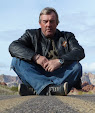
It wasn’t as simple as that for me at Christmas 2007 though. Something was different. I had passed my fiftieth birthday earlier in the year and I felt I needed a change. I needed to do something different and the Christmas break away from work that year gave me time to reflect. Time to think about what I wanted to do.

I have a great family with Jackie my wife and my three sons, Charles, Jeremy and Richard, plus my step-daughter Mish and her family. My lovely wife Jackie and I live a comfortable life in rural England, plus we have recently bought a house in Spain which was then being modernised to our tastes as a future place to spend time in. The boys are now in their late teens and early twenties and have all reached the stage where they are beginning to want to shape their own lives. They are making their own decisions. That christmas, it seemed like time was nearly right for a change.

My career has been successful and I am very lucky that I could soon retire. I had worked very hard since leaving school at sixteen and my work had given me a huge amount of satisfaction, but being honest with myself, I was tired. I had been in the same line of work for over thirty years. I had spent so many years of getting up early, so many years of the hectic pace of work, so many years of my life had centred largely around work, that it really was time for a change.

My work life had been about working out how to construct large construction projects – how the construction would be undertaken from a very practical point of view. I had worked on some fantastic projects including the preparations for the London 2012 Olympic Games. Looking ahead and setting out how things would be done was what I did and I was very good at it.

Christmas 2007 however had given me time to think. I am not sure if it was a mid-life crisis, but I felt I needed to do something else, but I wasn’t sure what. Then it struck me – since leaving school at a young age I had plunged headlong into work. Sure, I had enjoyed holidays every year and I had seen some great places in the world, but this was as a regular tourist. What was missing was I had never had any sort of an adventure that so many of my contemporaries had; no trekking around the world; no gap year excitement; no years of enjoying growing up as a young man in college environment, not even the school trip to China that one of my sons was about to enjoy. I needed an adventure!

With the potential for retirement in the near future, I spent that Christmas trying to decide what would fulfil that need for adventure. It surely had to involve travel of some sort, but what?

In my teens, I had loved motorbikes. I loved the sense of freedom, the independence, the mechanical side of the way motorbikes were built and to be honest, they were just damned great fun. From a Honda C70 to a 350cc two-stroke Yamaha through to a watercooled GT750 Suzuki, my teen years and early twenties had been about speed and having a lot of fun going fast, popping wheelies and doing all those things a young man takes a lot of pleasure from. However, lifestyles have to change and like many others before me, the early years of marriage and children meant that for me, the motorbike had to go – traded in for a series of bland but very practical cars.

That was until one day about a quarter of a century later, I was driving down the Kings Road in Chelsea, when being early for a business meeting, I decided to pop into Warrs, the Harley-Davidson dealer, just to have a look at what big motorbikes were like these days. I liked what I saw and I just had to try one of these huge shiny machines.

A few days later I was back at Warrs. I liked the look of the touring bikes, but these were much heavier bike than I had ridden many years earlier. Would I still like to ride? Could I actually ride such a big bike? I had to find out, so with some degree of trepidation, I rented a Road King for a few days and headed out onto the busy London streets to see if I still had the passion that I had once enjoyed.

It only took about an hour.

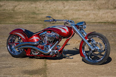
I loved the Harley. I loved its noise, its comfort, its image, the way people gave it admiring glances. I even loved the way the huge V-twin engine vibrated. I loved just about everything about it.

A day or so later saw me returning the rental bike to Warrs and ordering my own, brand new Harley-Davidson Road King. Black. Lots of extra chrome. Loud pipes. New leather jacket. New crash helmet. I was a born-again biker!

For the next year or so, I rode the bike a lot. I took it to France, Germany, Lichtenstein, Austria and just into Italy. I loved riding it!

So, Christmas 2007 had arrived and after the turkey had mostly been consumed, presents given and received, early episodes of the Two Ronnies and that ever-lasting duo, Morecombe and Wise had been watched for heaven knows how many times, thoughts turned to adventures. That first adventure had to be on a motorbike, but where to and for how long?

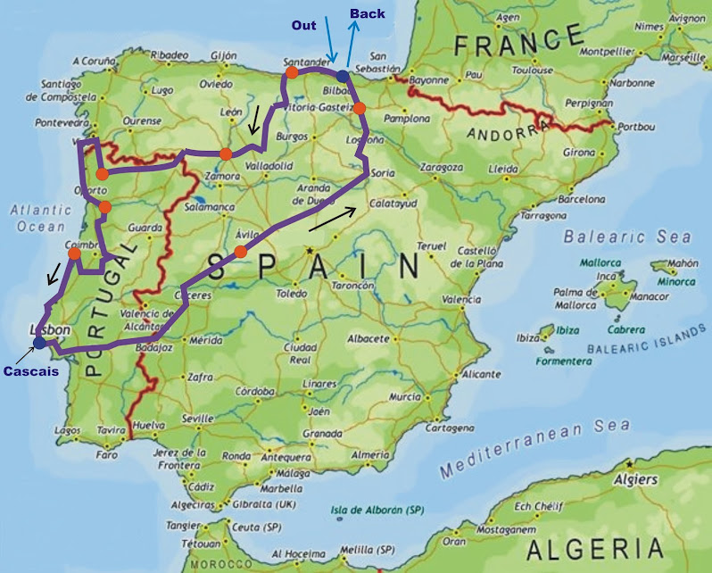
Two main locations became obvious front-runners – Europe or the USA. The USA pretty soon became the favourite. My initial idea was to ride in all of the 50 States, but after map consultations, a quick bit of route planning and a rapid mileage calculation, it became obvious that this was a tour that would take in the order of 6 months! Fifty States at, say, just half a week per State is 25 weeks! Half a week per State would hardly be an adventure, more an endurance race and not really what I had in mind. Time to think again.

I would need to visit less places over say three months and this was far more realistic. Where would I choose? How would I choose? Would I take my own bike or rent? Should I do this on my own, or in a group? So many questions, but I was determined to do this, so I called upon some of the skills and experiences I had been doing in my career for many years – time for some planning!

This blog sets out how I achieved my adventure, what route I planned, what I took with me, what I saw, what worked well, what didn’t work and records some of the highs and lows of the tour. I have written it for two reasons – firstly to record my own adventure and secondly, to help anyone else planning to do the same sort of tour. I hope that you enjoy reading at least some of it.